
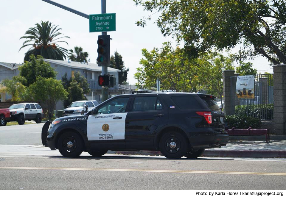
The San Diego Police Department’s main method of providing crime data to the public is through the crimemapping.com web application, according to San Diego Police Lt. Kevin Myer. | Photo Credit: Karla Flores, The AjA Project
By Kiran Mehta
![]()
Kiran Mehta is a high school student and a member of The AjA Project’s YAC Youth Media team.
Knowledge about the location and frequency of criminal activity is useful to law enforcement in that it helps them strategically plan how and where to direct their resources. It is beneficial to the community because it keeps people informed about public safety issues so they can remain vigilant and aware of their surroundings. There are online tools available to the City Heights community that serve this purpose. Among these are SpotCrime and CrimeMapping.com. Hoover High School students are also working to create a method to report crime in City Heights canyons.

Crime-mapping services report timely information about crimes, arrests and statistics so local residents may stay informed about the type and frequency of criminal activity within their community. | Photo Credit: Karla Flores, The AjA Project
SpotCrime and CrimeMapping.com
SpotCrime is a crime-mapping application and website that allows users to view crime statistics within San Diego and report a crime at a specific address. Although SpotCrime is one of the many crime-mapping applications available to the public via the web, the San Diego Police Department does not directly endorse the website or provide crime data to the site. By contrast, the Automated Regional Justice Information System (ARJIS) is an information-sharing network that provides statistical information and crime analysis data for government agencies. According to SDPD Lt. Kevin Mayer, CrimeMapping.com receives information from ARJIS for the entire San Diego region.
“CrimeMapping.com allows the public to generate maps and listings for certain crime types, in addition to the ability to sign up for alerts when crimes occur within a radius of a certain location,” Mayer said.
CrimeMapping.com displays crime data for the entire country, as well as the City Heights community. People can click on specific regions of the interactive map or type in an address and view the number and type of crimes reported by SDPD and ARJIS. The search can be narrowed to a certain period of time, ranging from one day to an entire year, and the search can be limited to particular types of crimes.
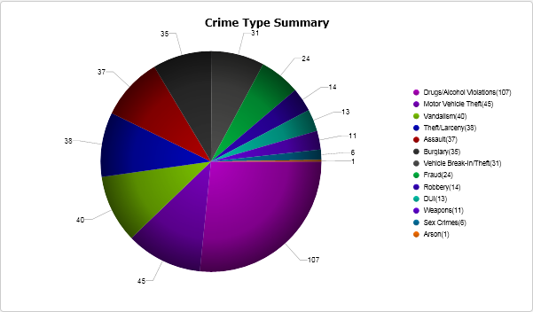
CrimeMapping.com reported 402 crimes within a two-mile radius of City Heights Community Recreation Center between March 25 and April 25, 2014. | Photo Courtesy of CrimeMapping.com
There is also a feature on CrimeMapping.com that generates a pie chart and bar graph indicating the frequency of each type of crime. For example, from March 25 to April 25, 2014, CrimeMapping.com shows that within a two-mile radius of the City Heights Community Recreation Center there were a total of 402 crimes committed. The pie chart indicates that drug and alcohol violations constitute about 27 percent of the total number of crimes in the City Heights region. Other frequent reports include motor theft, vandalism, assault and burglary.
Mapping Crime in Canyons
The Ocean Discovery Institute, an organization that works to educate and involve the City Heights community with its nearby canyons, offers the Watershed Avengers internship to Hoover High School students. As interns, the students identify issues and conduct scientific research to create a safe and healthy canyon environment. Part of the Watershed Avengers internship also involves working to understand crime and reporting through Ushahidi, a non-profit organization that developed online interactive maps reporting violence in Kenya. The Ocean Discovery Institute, in collaboration with the San Diego Police Department, is in the process of producing a similar method of collecting and sharing information about the canyons, including crime-related concerns. The Institute will be releasing information regarding the Hoover High School initiative within the upcoming year.
According to CrimeMapping.com, theft, burglary and robbery made up 21 percent of crimes in City Heights between March 25 and April 25, 2014. | Photo Credit: Karla Flores, The AjA Project
Generating a visual representation of crime rates within a specific mile radius allows people to understand the most frequent crimes committed in their communities. The San Diego Police Department urges people to utilize these resources to prevent crime and create a safer City Heights.